Discovering our heritage
Western Bay of Plenty - East and West

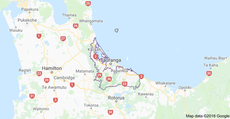
Western Bay of Plenty (see enlarged map here)spans from Waihi Beach to Otamarakau taking in the Kaituna Catchment, Kaimai, the Wairoa River and Tauranga City. Mauao (Mt Maunganui) sits at its heart.
The region covers 212,000 hectares of coastal, rural and urban areas, much of which is considered as Taonga, meaning a natural treasure. This region is steeped in New Zealand Māori and colonial history, culture & heritage and is New Zealand's fastest growing region today.
The region covers 212,000 hectares of coastal, rural and urban areas, much of which is considered as Taonga, meaning a natural treasure. This region is steeped in New Zealand Māori and colonial history, culture & heritage and is New Zealand's fastest growing region today.
The earliest known settlers to the Western Bay of Plenty in the 13th century were Māori from the following waka:
At 9.00 am on Friday 23 June 1826 The Herald was the first NAMED European ship to enter Tauranga Harbour, 'Tauranga' meaning 'safe harbour', albeit it is well known that other ships carrying Europeans arrived earlier than this.
- Te Arawa: which first arrived at Maketū and today forms part of the Te Arawa Coastal & Waitāha Tangata whenua of Western Bay of Plenty | EAST which covers the area inland from Ōtanewainuku, Te Puke down to Maketu and onto
- Mātaatua came first into the Whakatane region whose peoples migrated west to form what we know as Ngāi Te Rangi and Ngāti Pukenga iwi today:
- Tākatimu came first with its peoples evolving into Ngāti Ranginui today.
At 9.00 am on Friday 23 June 1826 The Herald was the first NAMED European ship to enter Tauranga Harbour, 'Tauranga' meaning 'safe harbour', albeit it is well known that other ships carrying Europeans arrived earlier than this.
Western Bay of Plenty, west
The western area of the Western Bay of Plenty district is known as Tauranga Moana (Waihi Beach / Bowentown to Pāpamoā) and was first occupied by the iwi of
Read more about the iwi here
The western area of the Western Bay of Plenty district is known as Tauranga Moana (Waihi Beach / Bowentown to Pāpamoā) and was first occupied by the iwi of
- Ngāi Te Rangi
- Ngāti Pūkenga
- Ngā Pōtiki
- Ngāti Ranginui
Read more about the iwi here
Western Bay of Plenty, East
Was first settled by the Te Arawa iwi from the Te Arawa waka. Read more about the iwi here
Was first settled by the Te Arawa iwi from the Te Arawa waka. Read more about the iwi here
|
Western Bay of Plenty Recollect - Archives
Learn more about the history of Western Bay of Plenty West and East here |
Tauranga City
Tauranga city sits remarkably in the centre between east and west and this is landmarked by MAUAO or Mt Maunganui - or 'The Mount' many still call it.
Tauranga city sits remarkably in the centre between east and west and this is landmarked by MAUAO or Mt Maunganui - or 'The Mount' many still call it.
HOME
ABOUT: Our Team | Ōtamataha Pā | Taonga - our treasure | Our brand story
WHATS ON: Exhibitions | Past Events | Videos
DISCOVER: Our Tāngata whenua | Early Tauranga | Waihi Beach | Katikati | Mauao - the legend | The Kaituna | Te Puke | Maketu - magic
OUR HERITAGE: Heritage Collection | Heritage Gallery | Battles of Gate Pā & Te Ranga | The Apology | St George's Gate Pā | The Elms |
Historical Society | Tauranga Jazz Festival History | Maori Proverbs | Heritage Organisations | Archives | The Golden Years
HERITAGE FRIENDS
CONTACT
Content Copyright Organic Living Ltd © 2022


